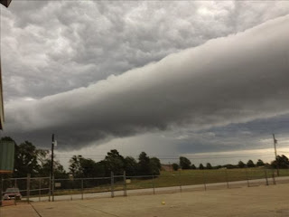
Scared the Shitacky outta me when I saw this on the news 11-13-2013!
Yes,indeedy_imagine driving down the street,road,etc..and this puppy is just above your head! They are called "Roll Clouds".Need I say more....
So,let me do some explaining.According to folks that know this kinda stuff_A Roll cloud is a kind of Arcus Cloud_which is a low, horizontal cloud formation. Roll clouds and shelf clouds are the two types of Arcus clouds. A Shelf cloud is usually associated with the leading edge of a thunderstorm outflow _while_ Roll clouds are usually formed by outflows of cold air from sea breezes or cold fronts in the absence of thunderstorms.
Here's a shelf cloud with a thunderstorm....
It is my understanding that a Roll Cloud is a low,horizontal,tube -shaped, and relatively "RARE" type of Arcus Cloud.They differ from shelf clouds by being completely detached from other cloud features. Roll clouds usually appear to be "rolling" about a horizontal axis. They are a solitary wave called a "SOLITON", which is a wave that has a single crest and moves without changing speed or shape. One of the most famous frequent occurrences is the Morning Glory Cloud in Queensland, Australia which can occur up to four out of ten days in October! Yes!,that's 4 days out of 10...I'd be on the next flight out of "The Queens-Land"! Here's a look-see taken from an airplane......
A "Morning Glory" cloud is a "Roll Cloud" that can be up to 620 miles long, up to 1.2 miles high, often only 330 to 660 feet above the ground and can move at speeds up to 37 miles per hour. Sometimes there is only one cloud, sometimes there are up to eight consecutive roll clouds....Do you have that visual, yet?
The Morning Glory is often accompanied by sudden wind squalls, intense low-level wind shear, a rapid increase in the vertical displacement of air parcels, and a sharp pressure jump at the surface. In the front of the cloud, there is strong vertical motion that transports air up through the cloud and creates the rolling appearance, while the air in the middle and rear of the cloud becomes turbulent and sinks.
So,I'm thankful we didn't have "The Motherlode of Roll Clouds"_nevertheless_I'm sure folks in the East Texas towns of Tyler,Longview,etc..(my home base BTW)_had a "WT? Moment"_when they saw this...
http://www.kltv.com/slideshow?widgetid=54121
On November 4th in Canyon,Texas miles, miles away from East Texas_ yet another Roll Cloud.Wanna hear what it sounds like ?
http://weather.aol.com/2013/11/11/watch-amazing-roll-cloud-stretches-across-texas-sky
Todd Mask captured it on video, describing the cloud as "rolling like an ocean wave" and "like a horiztonal vortex.
All this Roll Cloud business_got me to thinking /humming a TV Show theme song from my childhood..."Rawhide"...just sayin'
More importantly_First Canyon,Texas_Now East Texas_"Is Texas primed for adding this "Rare Roll Cloud" event to it's LIST of Scary Weather conditions"? I will.....
Just in case, I need to stock up on "Charmin' Tissue"...
For ...
Guess I'll Roll outta here...Happy Friday!


No comments:
Post a Comment